
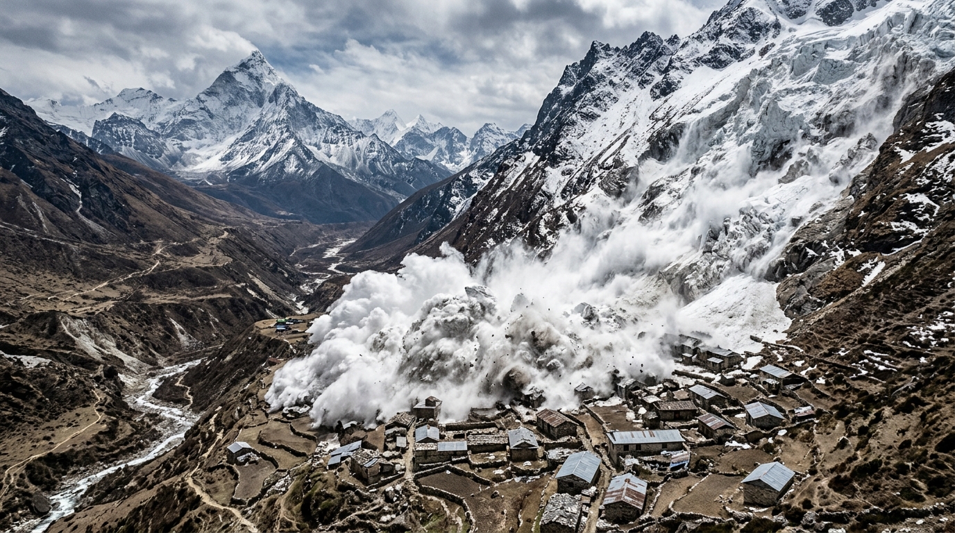
More than 330 dead, more than 1,500 missing, entire villages wiped off the map within a few minutes: the toll emerging from Nepal’s valleys near the Tibetan border is enough to make one’s head spin. Yet what makes this catastrophe even more unsettling is where it came from. No major earthquake announced, no exceptional seasonal downpour, and yet a mud-and-water wave swept across settlements located roughly thirty kilometers from the source, at an altitude of more than 5,200 meters. How could a simple slab of glacier, perched on a remote flank of the Himalaya, unleash such a disaster downstream? The answer lies in a phenomenon scientists call a cascade of risks, a chain reaction of geological dominoes that Nepal has just experienced in stark reality.
A magnitude-5.2 tremor that wasn’t an earthquake
Early Wednesday morning, instruments of the United States Geological Survey recorded a tremor of magnitude 5.2, equivalent to a modest earthquake. At first glance, everything pointed to a conventional seismic event. But a deeper analysis of the waveforms quickly revealed the true origin: not a fault slip, but the impact of a glacial collapse and a massive landslide of debris. In other words, it wasn’t the ground that shook first, but tons of ice and rock that peeled away from a slope, generating a shock wave strong enough to be mistaken for an earthquake. Satellite imagery suggests these debris fell down into the Lhende Kola river valley from an altitude of around 5,200 meters, a breaking point well above inhabited areas.
Nine meters of water in thirty minutes: the anatomy of a disaster
Perhaps the most vertiginous datum of this event. In the municipality of Galchhi, about 33 kilometers west of Kathmandu, a measuring station still in operation recorded a rise in water levels of nine meters in just thirty minutes on the Trishuli River. A liquid wall, loaded with sediments and debris, that devastated buildings and swept away bridges along its path, as videos circulating on social networks show. Faced with the risk of further floods, authorities urged residents to stay away from the banks of the Bhotekoshi, Narayani (also called Gandaki or Gandak), and Trishuli. The irony is that this episode unfolds during the monsoon season, without heavy rainfall being the direct cause.
The cascade of risks: when a high-altitude fissure becomes a mud tsunami
To understand how a simple instability high in the mountains can turn into a downstream catastrophe, imagine a chain reaction. A portion of a glacier detaches from a weakened slope and races downhill as a glacier-ice and rock avalanche. This mass can then temporarily dam the bed of a river, creating an unstable natural barrier. When this barrier fails, the accumulated water is released violently, carrying with it enormous amounts of sediment and debris, and transforming into a flood capable of traveling tens of kilometers downstream. It is this exact mechanism, well known to mountain-risk specialists, that seems to have struck the Lhende Kola valley before propagating to Galchhi and beyond. The danger lies less in each phenomenon in isolation than in their sequence, which can turn a localized high-altitude failure into a tragedy for populations far below, far from any obvious warning signs.
Glaciers, permafrost, unstable lakes: the Himalaya under surveillance
It would be tempting to attribute this event to climate change alone, but caution remains warranted: we still don’t know why this particular glacier collapsed at that exact moment. What is clear, however, is that conditions across the Hindukush-H Himalaya chain are changing rapidly. Glaciers are retreating, permafrost is degrading, new glacial lakes form at high altitude, and slopes that were once stable become exposed and fragile. Global warming may not be the sole cause of every collapse, but it acts as an amplifier of existing risks, shifting thresholds beyond which one phenomenon triggers another. And the danger does not end with the recession: the debris deposited can raise river beds, alter courses, or form new temporary barriers, all of which can pose threats again in the days, weeks, or even years ahead. Hence the authorities’ expectation of a continuing risk of second and third waves in the days to come, even without significant rainfall.
What Galchhi reveals about the future of the Himalayan valleys
Beyond the human tragedy, this catastrophe sheds light on a broader reality: a Himalayan landscape where risks can no longer be viewed in isolation. The lesson is clear: we must think in terms of risk chains rather than standalone events. Practically, this means combining satellite monitoring of glaciers, lakes, and unstable slopes with seismic data and river-flow measurements to build early-warning systems capable of detecting a cascade at its onset, well before it reaches populated areas. It also requires rethinking infrastructure, evacuation plans, and land use in these valleys, incorporating the probability of future disasters rather than merely reacting after the fact.
For now, field research continues, conducted jointly by Nepalese and Chinese agencies, as authorities search for the many people still missing. This event serves as a stark reminder, with chilling clarity, that the heights of the Himalaya—though distant and silent—are inextricably linked to the fate of the valleys far below. A crack invisible at 5,200 meters can redraw entire lifelines dozens of kilometers away. The question now is how many more cascades of risk lie dormant, silent, in the glaciers that crown the world’s roof.
