
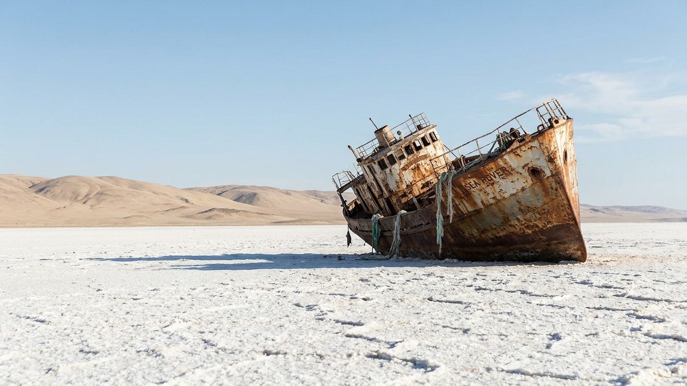
In Moynaq, Uzbekistan, the rusted hulls of trawlers lie buried in the sand, tens of kilometers from the nearest drop of water. These metal wrecks once belonged to a thriving fishing fleet. Today, they are the remnants of one of the worst human-made environmental disasters of the 20th century: the near-complete disappearance of the Aral Sea.
Numbers tell their own story. Located between Kazakhstan and Uzbekistan, the Aral Sea, once the fourth largest lake in the world, continues to shrink and has lost more than 90% of its original surface area since the 1960s. A study relayed by several scientific sources confirms this scale: the Aral Sea has lost about 90% of its volume since the 1960s due to water diversion for irrigation. Before this collapse, the sea covered roughly 68,000 square kilometers, a touch larger than West Virginia, before shrinking to about 10% of that size and splitting into two distinct bodies of water.
Key takeaways
- A 1960s political decision transformed the fourth largest lake into a white salt desert
- Rivers diverted for Soviet cotton delivered only about 40% of their water to the fields
- Kazakhstan built a dam that brings life back to the north, while the south sinks deeper into ruin
Soviet cotton, directly responsible for the drying up
It all began with a political decision, not a whim of the climate. The Aral Sea started to retreat in the 1960s when Soviet engineers diverted the two rivers that fed it, the Amu Darya and the Syr Darya, to irrigate the cotton fields of Kazakhstan and Uzbekistan. The Soviet objective was clear: to transform Central Asia into the textile factory of the Eastern Bloc, even if it meant sacrificing an inland sea that had existed for millions of years.
The irrigation system that was built was alarmingly inefficient. There are about 48,000 km of main and secondary canals and 360,000 km of irrigation ditches in the Aral basin, with only about 28% of the total length lined. The result: a large portion of the water drawn from the rivers did not even reach a single cotton field; it evaporated or seeped away along the way. Studies cited by specialists estimate that the average irrigation efficiency delivered to crops across the Aral region was only about 40%. We dried up a sea to water crops, and more than half of that water never reached its destination.
The turning point happened in two stages. The diversion triggered a rapid contraction of the sea, and in the 1960s it had already lost more than half of its volume; by the 1980s, the sea had split into two separate bodies of water, the North Aral Sea and the South Aral Sea. This split sealed the fates of the two basins in radically different ways, one heading toward a slow death, the other toward a nascent revival.
Moynaq, the port turned desert
It is impossible to tell this story without mentioning Moynaq, the former Uzbek port transformed into a global symbol of the disaster. Today, there remains only a white desert of salt and sand, speckled with rusted hulls whose gaping, torn sides resemble stranded whales. The town once supported a thriving fishing industry: at the height of its activity, Moynaq’s canneries could produce up to 20 million tons of fish each year, destined for export to the far corners of the USSR.
The exodus was massive. The town’s population was reduced by a factor of five and unemployment hovered around 50%, while more than a million people left the entire region to seek work elsewhere. The desert that replaced the sea is not an ordinary desert: it is saturated with salt and pesticide residues accumulated over decades of intensive agriculture. The wind handles this and disperses the toxic dust for hundreds of kilometers, worsening respiratory problems among local populations.
Kazakhstan bets on a dam, a glimmer of hope
Not everything is lost everywhere. On the Kazakh side, a dam changed the equation. In 2005, the Kazakh government, backed by the World Bank, built a 12-kilometer-long dam, Kokaral, which separates the North Aral Sea from the South Aral Sea, with the aim of reducing the amount of water flowing south and thus raising the northern water level. The results exceeded even the engineers’ expectations: with a rise of 3.3 meters in the water level after seven months, the outcomes were better than anticipated, the dam having increased the North Aral Sea’s water level by several meters and making ecological restoration and the return of fish possible.
On the Uzbek side, the situation remains far bleaker. The Great South Aral Sea has basically disappeared, leaving only a shallow, hypersaline stretch incapable of supporting meaningful aquatic life. Two countries, two trajectories: to the north, a sea that is slowly coming back to life; to the south, a desert that is gaining ground each year. That is the irony of this catastrophe, born from a single decision whose consequences have been distributed in radically unequal ways between the two shores.
Tourism, meanwhile, has seized on this tragedy with a mix of fascination and discomfort. Moynaq’s wrecks have become one of Central Asia’s most photographed sites, drawing visitors from around the world to behold this post-apocalyptic landscape. Some local guides see it as a welcome economic opportunity for a region that is drying up; others fear a form of disaster tourism that does little to address the underlying issues.
The future of what remains of the Aral Sea depends on a factor no one can truly control: the glaciers of the Himalayas and the Tian Shan that feed the Amu Darya and Syr Darya. Climate projections cited by researchers suggest that glacier melting will temporarily boost river flows, with a peak runoff expected around 2040, before water supplies fall again as the glaciers shrink, the peak timing shifting by about a month earlier due to higher temperatures. A hydrological time bomb that, in the long run, threatens the five Central Asian countries long after the last drop has left the bed of the former sea.
Sources: lecamulogene.fr | chroniques-de-voyages.com
