A ribbon of floating seaweed now sprawls across the tropical Atlantic, an organic archipelago so large it can be seen from space. Scientists call it the Great Atlantic Sargassum Belt, a mobile mass of brown algae that has stitched together waters from West Africa to the Caribbean and the Gulf of Mexico—roughly 8,850 kilometers, or about 5,500 miles. “It’s a system we thought we understood—until it grew wider, denser, and far more unpredictable,” one researcher remarked.
What exactly is drifting out there?
Sargassum is a pelagic seaweed that floats freely, buoyed by tiny gas-filled bladders. It forms mats that aggregate into rafts, sheltering young turtles, fish, and countless invertebrates. Far offshore, those mats are a nursery, a living oasis in nutrient-poor waters.
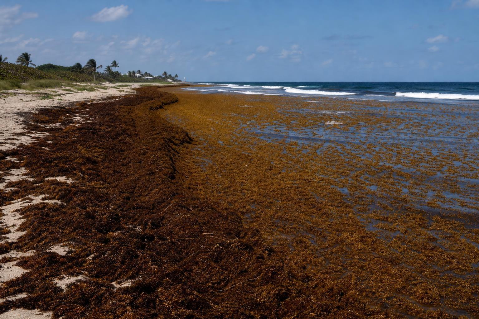
But when relentless winds and currents shove the rafts landward, they can pile up on beaches in stinking, knee-deep banks. “Offshore it’s habitat; onshore it’s hazard,” says a coastal ecologist. The difference is distance, timing, and sheer volume.
Why has it grown so immense?
Multiple drivers are feeding this super‑bloom, and they don’t act in isolation.
- River-borne nutrients from the Amazon, Orinoco, and Congo, amplified by deforestation and fertilizer runoff.
- Iron-rich Saharan dust that fertilizes the surface ocean.
- Warmer waters and shifting currents linked to climate variability.
- Upwelling of deep, nutrient-rich water in key regions.
Put simply, the Atlantic has become more fertile along the seaweed’s pathway. “Feed the ocean, and you feed the bloom,” as one ocean modeler put it.
A boon at sea, a burden ashore
In open waters, Sargassum is life‑support. It offers shelter and food, attracting mahi‑mahi, jacks, juvenile turtles, crabs, eels, and even seabirds on the hunt. Fishers sometimes track the mats for catches they otherwise wouldn’t see.
On beaches, the same biomass rots into trouble. Decomposition releases hydrogen sulfide and methane, creating noxious fumes that sting eyes and throats. Thick wracks smother seagrass beds, bury turtle nests, and trigger nearshore hypoxia that can kill fish and invertebrates. Tourism-heavy islands report lost revenue, clogged marinas, and spiraling cleanup costs.
How we know it’s there
The belt is mapped by satellites—MODIS, Sentinel‑3, and commercial platforms that can distinguish Sargassum’s spectral signature. Analysts convert pixel patterns into estimated tonnage, then feed those data into models to predict landfall windows. Local reports, drone surveys, and smart booms close the loop, updating forecasts with real‑time observations.
These tools have transformed a mystery into a managed risk, though the yearly amplitude remains volatile. Some years swell to near‑record loads; others ease with changing winds and river flows.
Cleanup is harder than it looks
Collecting Sargassum is gritty, time‑sensitive work. Beach rakes can scar dunes, crush turtle nests, and shred seaweed into finer mulch that’s harder to remove. Heavy equipment compacts sand, degrading natural barriers against storm surge. Offshore skimming keeps biomass away from shores, but it risks bycatch of juveniles using the mats as refuge.
Managers now talk about “lighter‑touch” operations: deploy offshore booms to corral incoming rafts, shift to amphibious vehicles with lower footprints, and time cleanups to avoid nesting peaks. “Move early, move carefully, move with a plan,” says a coastal manager.
Can we turn a mess into a resource?
There’s a surge of interest in valorizing the biomass—into composts, biochar, biogas, construction panels, and even seaweed‑based leathers. Some startups propose biofilters to strip salts and arsenic, contaminants that complicate fertilizer or feed uses. Others test mild pretreatments to unlock alginates and polymers while keeping toxins out of food chains.
Caution remains vital: arsenic and heavy metals can accumulate, and poorly managed piles leach into groundwater. The safest pathways are industrial, not edible, with clear standards, traceable sourcing, and transparent testing.
Living with a moving target
The belt is not a static wall but a restless, seasonal phenomenon. It typically intensifies from late spring through summer, with hotspots sliding along currents and river‑plume edges. Some years the Gulf sees heavy landings; in others, Caribbean islands bear the brunt. Local weather can mean the difference between a near‑miss and a knee‑deep inundation.
Communities that fare best mix early warnings, coordinated response, and steady public communication. Hotels reshape beachfronts, ports deploy booms, and fisheries adjust effort to floating fronts rather than fixed grounds. Insurance, public‑health guidance, and island‑to‑island cooperation complete the toolkit.
What the surge is telling us
This expanding belt is an indicator as much as a nuisance. It signals a nutrient‑rich Atlantic, stressed coastal waters, and a climate system that is tilting distributions we once thought stable. “The ocean is speaking in brown and gold,” a scientist said. “Our job is to listen, adapt, and act with precision.”
For now, the brown ribbon keeps drifting, flipping between boon and burden with every shift of wind and tide. Whether it grows, shrinks, or simply shifts its seasonal dance will depend on rivers, runoff, dust, and a warming sea that is rewriting the Atlantic’s floating script in real time.