
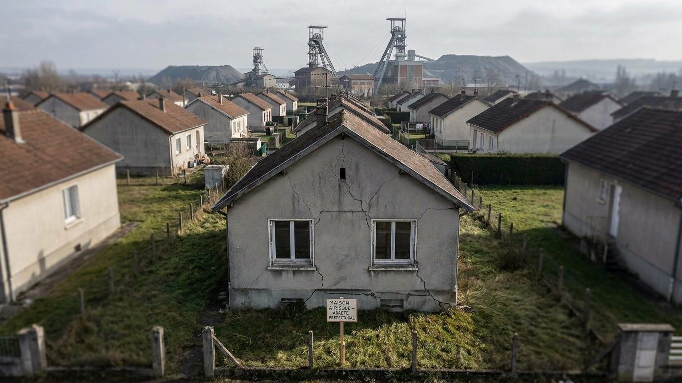
For more than a century, iron ore extraction, the “minette,” left a subsoil pocked with voids beneath a belt stretching from Longwy to Nancy, passing through Briey and Moyeuvre-Grande. The Lorraine iron-ore basin lies largely to the west of a Thionville–Metz–Nancy line and covers more than 2,545 square kilometers, where iron ore was mined industrially from the early 19th century until 1997. While the mines operated, pumps worked relentlessly to evacuate the infiltrations of water that naturally gathered in the galleries: this is the dewatering system. An invisible mechanism to the general public, yet on which the stability of an entire territory depended.
When profitability collapsed, the economic logic did the rest. When the last Lorraine iron mines closed, between the late 1980s and the mid-1990s, operators gradually halted this pumping. Without pumping, water rises, drowns the galleries, and the supporting pillars that had held the subsoil for decades begin to chemically degrade. The rock gives way, a void propagates to the surface, and the ground finally collapses all at once, sometimes in the form of fontis—those funnels that abruptly appear in a garden or beneath a roadway. “There is an undeniable link between the rising waters in the galleries and the sinking of the ground. This happened already in Auboué in 1996, then in Moutiers, Roncourt, or Moyeuvre-Grande in 1997 and 1998,” summarized Colette Goeuriot, president of the Collective of Lorraine mining municipalities. In Moutiers precisely, a collapse in 1996 led to the evacuation of homes deemed at risk, an episode that left a lasting mark on the basin’s memory.
L’après-mine : qui porte la responsabilité une fois l’exploitant parti
The problem is that the mining companies that should have repaired the damage largely disappeared. Mining damage had been the miners’ daily reality during 150 years of intense extraction, but the operator repaired the damage and informally rehoused families whose houses were damaged or destroyed. Yet, current collapses occur ten, twenty, or even fifty years after the shutdown, and many operators have vanished. This break in the continuity between exploitation and its consequences forced the State to organize public risk management: this is what is called the post-mining era.
The turning point came just after the Auboué crisis. In 1996, the events in Lorraine’s iron mines, notably in Auboué, highlighted the risks that persist after subsoil exploitation, pushing BRGM and INERIS to structure their joint activity by creating a support hub named GEODERIS. This group, later established as a national public-interest group (GIP), conducts technical expertise: it assesses hazards, maps risk zones, and feeds the mining risk prevention plans that prohibit or regulate construction in sensitive sectors. The concrete implementation of safety works, however, falls to the Department of Prevention and Mining Safety, a BRGM entity. A government decree of 4 April 2006 assigned all operational functions to BRGM, which created specifically for this purpose a dedicated service, the Department of Prevention and Mining Safety, responsible since 2006 for monitoring and risk prevention on former mining sites on behalf of the State. In plain terms: since the State issued the mining concessions originally, it is up to it to guarantee safety once the operators have left.
Une surveillance pensée pour durer des décennies
The Lorraine iron-ore basin is unique in that its subsoil never fully stabilizes. A former regional director of industry in Lorraine summed up the situation bluntly: “In the iron-ore basin, the monitoring system for the galleries will be almost eternal.” Practically, this translates into a network of micro-seismic sensors and piezometers that continuously monitor ground movements and the water levels in the flooded mining reservoirs, in order to detect the smallest anomaly before it surfaces.
This monitoring accelerated again in the late 2000s, when the last major sectors in the northern part of the basin were flooded in turn. The flooding of the remaining Lorraine iron mines began in late November, signifying that the water seeping into the galleries would no longer be pumped—a decision taken by the regional prefect after consulting experts from DRIRE, Geodéris, INERIS, and hydrogeologists, who deemed the flooding irreversible. Since then, monitoring rests on a simple principle: it is better to anticipate instability than to discover it beneath the foundation of a house. The zones identified as at risk remain subject to strict urban planning rules today, a direct legacy of the 1990s catastrophes.
La Lorraine n’est pas un cas isolé en France
The Lorraine scenario—halt of exploitation, then flooding, then surface risk—has repeated elsewhere, at varying paces depending on the resources mined. The end of large mining operations began in the 1990s: coal mining stopped in the early 1990s in the north; iron mining ceased in 1997 in Lorraine; uranium mining ended in 2001 at Jouac in Limousin; potash in 2002 in Alsace; and the last coal shaft closed in April 2004 at La Houve in Lorraine. Each of these basins—the northern and Lorraine coal basins, Alsatian potash, Limousin uranium, among others—follows its own inundation curve and its own risk zones, monitored by the same national authorities: GEODERIS for expertise and BRGM’s DPSM for field operations. The Auboué and Moutiers lesson has spread far beyond Lorraine: wherever a mine has fallen silent, water eventually reasserts its rights, and no one can say with certainty when it will finish redrawing the subsoil.
Sources: fresques.ina.fr | lemoniteur.fr
