
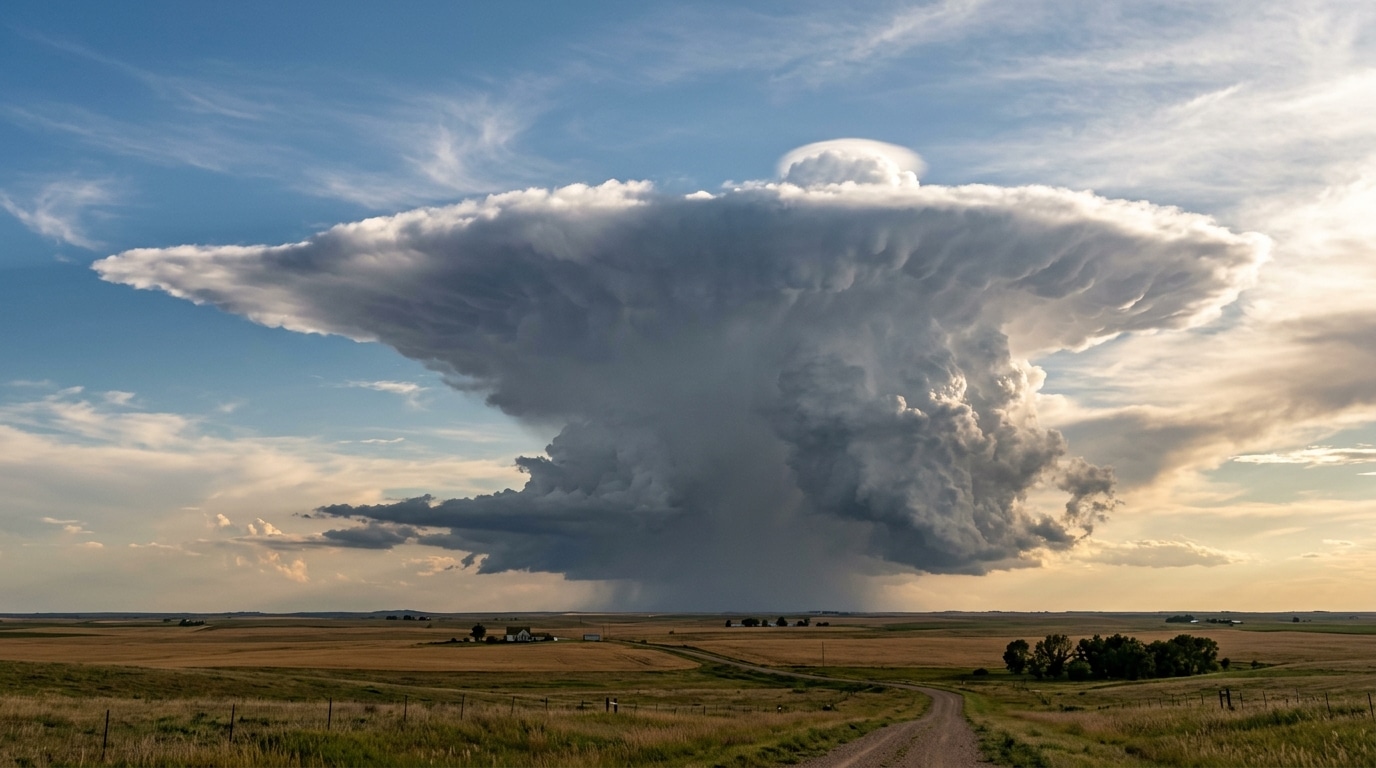
Early November, the Southeast of France experienced another Mediterranean episode, with torrential rains forecast for the night from Tuesday, November 3 to Wednesday, November 4, expected to continue without interruption until Thursday, November 5. The coastal departments of Var, Bouches-du-Rhône, Gard, Hérault, Aude, and Pyrénées-Orientales were placed on the front line, with rainfall totals potentially reaching 200 mm between November 4 and 6 according to forecasts. Behind these striking numbers lies a very specific actor in the stormy sky: the cumulonimbus, that cloud capable of climbing to dizzying heights before abruptly spreading into a shape recognizable above all others, the anvil. Understanding why this giant of the sky inevitably flattens at the top helps read the warning signals before a storm.
- The cumulonimbus broadens into an anvil when its ascent encounters the stable layer of the tropopause, which slows its vertical progression.
- An overshooting top, a protuberance extending above the anvil, signals a very powerful updraft and an increased risk of giant hail, tornadoes, or violent gusts.
- Since September 2026, Météo-France’s vigilance provides infra-departmental information for thunderstorms, useful before any outing in the Southeast.
- When the storm seems determined to pierce the sky without limit
- Why the top of the cloud ends up hitting an invisible wall
- How the updraft turns into an anvil silhouette
- When the power of the storm still overcomes this barrier
- What this shape teaches us about storm mechanics
When the storm seems determined to pierce the sky without limit
A cumulonimbus in full formation often seems to have no intention of stopping. It grows, stretches, climbs higher at a speed that can surprise even the most seasoned observers. This ascent is by no means trivial: the warm, humid air currents feeding the cloud can exceed 100 km/h in vertical speed. It is precisely this kind of instability, linked to a cold pool moving toward the Bay of Biscay and to a southeast to east flow, that sustained wet and unstable conditions from the Roussillon to Corsica in early November. Keraunos even reported that nine departments around the Mediterranean and Corsica were exposed to thunderstorm risk that Wednesday, from the Gard to Haute-Corse via Aveyron and Tarn. Faced with such energy, one might think nothing stops the cloud’s progression toward the stratosphere.
Why the top of the cloud ends up hitting an invisible wall
And yet, this meteoric rise almost always encounters a limit. The cumulonimbus develops vertically until it meets a layer of stable air at the base of the stratosphere. This zone, close to the tropopause, acts as a true atmospheric ceiling: the air there is much more stable than in the troposphere where the cloud grew. The updraft, which had been shooting straight upward, is suddenly slowed. This isn’t a hard wall, of course, but an obstacle that the rising air cannot easily cross. It is at this precise moment that the cloud dramatically changes its appearance.
How the updraft turns into an anvil silhouette
Stalling in its vertical progression, the updraft has no choice but to spread laterally. This is exactly what NASA describes, explaining that this stable layer acts as an obstacle without being an entirely impenetrable ceiling. The cloud then takes the form of an anvil or plume. The World Meteorological Organization’s International Cloud Atlas classifies this configuration under the name cumulonimbus capillatus, recognizable by the presence of fibrous or striated cirrus-like elements at its upper portion. This structure can draw a true anvil, an elongated plume, or a large disordered mane depending on the conditions. In very cold air masses, these filaments can even extend across nearly the entire cloud. This type of cumulonimbus is often accompanied by showers, thunderstorms, hail, and sometimes hailstones, and frequently gives rise to clearly visible virga.
When the power of the storm still overcomes this barrier
This atmospheric barrier is nevertheless not insurmountable for all storms. Some updrafts, particularly strong, manage to produce temporary overshoots above the anvil. This is known as an overshooting top, a protuberance that literally pierces the cloud’s summit and crosses the tropopause. This phenomenon is never trivial: it signals an extremely powerful updraft, and thus an increased risk of giant hail, tornadoes, or violent downbursts. It is precisely this kind of intense instability that fuels the most notable episodes of the season. Summer 2026, in fact, offered a striking snapshot, with 243,649 lightning strikes detected between June 1 and August 31 according to Météorage, a subsidiary of Météo-France, making France the second most lightning-struck country in Europe during that period. July 16 remained the most lightning-filled day of the year with more than 20,300 strikes, ahead of August 24 and its 19,600 strikes. All these signals remind us that a simple anvil-shaped cloud can conceal formidable electrical activity.
What this shape teaches us about storm mechanics
Spotting an anvil in the sky is therefore not merely an aesthetic concern. It is a precious clue about the state of the atmosphere and the strength of the developing storm system. If a protrusion rises clearly above, it is wise to stay vigilant: it signals an extremely powerful updraft. Moreover, since September 2026, Météo-France’s vigilance provides infra-departmental information for four additional phenomena: wind, rain-flooding, snow-ice, and storms, in addition to avalanches and storm-surges. This information, presented visually and concisely, fits into a context where the first Cévennes episode of the season in late September had already placed three departments on orange vigilance. A good reflex to adopt: regularly consult this map before heading out for hiking, sailing, or a stroll in the Southeast, especially when a charged sky begins to take this characteristic anvil silhouette.
Ultimately, what seemed like an endless ascent always finds its limit somewhere between the troposphere and the stratosphere. This meeting between rising air and a more stable layer shapes one of the most recognizable spectacles in the stormy sky, but it also serves as a reminder that behind every anvil lies a precise, sometimes formidable mechanism that is worth knowing how to read before stepping outside.
Sources: Glossaire météo et climat (meteofrance.com) | IRM – Cumulonimbus (meteo.be)
Article prepared with the help of an AI · Our method