
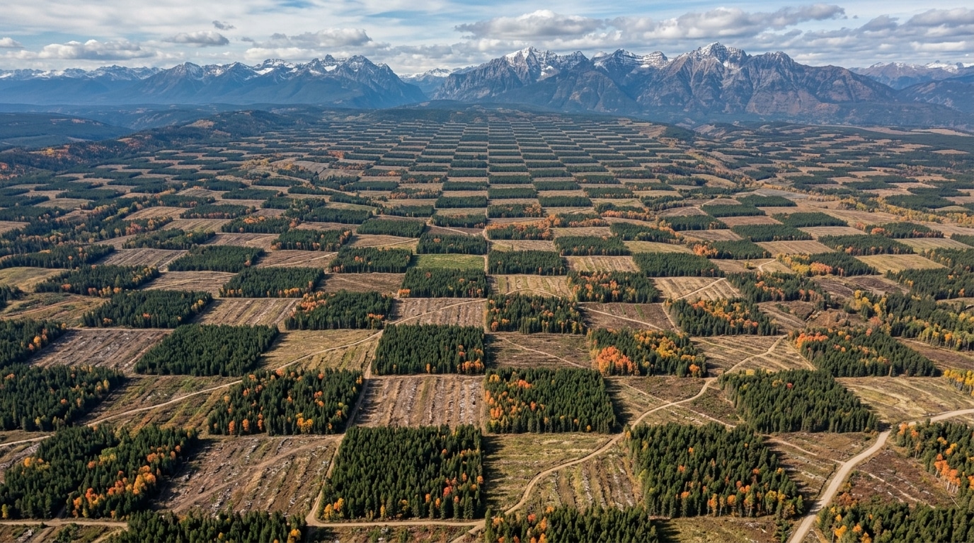
Open Google Maps over Oregon or Wyoming, zoom in on a forest that looks wild, and a strange pattern emerges: a vast checkerboard, square after square, sometimes spanning hundreds of kilometers. This design is not natural. It traces back to a law more than a century and a half old, and it continues to determine today who has the right to cut what.
- The Pacific Railway Act of 1862 created a checkerboard by ceding one section in two to railroad companies, leaving the other sections in the federal public domain.
- This pattern now alternates between public parcels protected by the Bureau of Land Management and privately owned parcels logged on a bare-bones basis, creating contrasts visible from space.
- The Supreme Court declined to hear a challenge to the “corner crossing,” thereby making this practice—allowing people to traverse the corners between public parcels—legally settled in six states.
- A giant grid carved into the forest for more than 150 years
- When the state ceded land block by block to settlers and railroad companies
- Why some parcels stayed wild while their neighbors were razed
A giant grid carved into the forest for more than 150 years
On satellite images of certain western regions of the United States, the forest looks like a giant board game. Densely wooded squares alternate with clear-cut or thinned parcels, forming a near-perfect checkerboard that sometimes stretches for dozens of kilometers. This is not a coincidence of local forest management.
Each square in this grid corresponds to a section, namely a one-square-mile unit—the basic unit of the American cadastre. One square on every side belongs to the federal government, the other to private owners or to timber companies. The result: neighboring parcels can have radically different fates, one protected, the other logged to the bone.
This division is not a recent accident in history. It dates back to the 19th century, when the U.S. government sought to populate and connect the West with the railroad. The administrative scars of that policy remain visible today, to the naked eye, from space.
When the government ceded land block by block to settlers and railroad companies
On July 1, 1862, Abraham Lincoln signed the Pacific Railway Act, a measure designed to speed up the construction of the transcontinental railroad. Rather than directly funding the work, the government ceded land to railroad companies along the tracks, one square out of two, leaving the other squares—described as the even-numbered sections—in the federal public domain. The checkerboard was born from this straightforward administrative split.
The original text allotted five alternating sections per mile of track, on each side, within a ten-mile limit. Two years later, an amendment doubles the stake: ten alternating sections per mile, across a twenty-mile width. Since each section equals a square mile, or 640 acres, the railroad company could receive up to 12,800 acres per mile of track laid, compared with 6,400 acres initially.
Across the nation, the total adds up to dizzying sums. In all, 79 grants of this type were made, representing about 200 million acres of public lands handed to railroad companies, a surface later reduced to 131 million acres after various retrocessions and legal disputes. In parallel, the Homestead Act of the same year allowed settlers to occupy the federal sections, completing this grand land-sharing by block.
In 1866, it was the Oregon and California Railroad’s turn to receive its slice, to connect Portland to California. The granted parcels then encompassed an intact Douglas fir forest, a flagship species of the Pacific Northwest. For lack of sufficient sales, Congress stepped back in 1916 with the Chamberlin-Ferris Act, which returned about 2.5 million acres of unsold Oregon & California lands to the federal government—precisely those lands that still fuel debates today.
Why some parcels stayed wild while their neighbors were razed
Sixteen decades later, this grid continues to dictate the fate of every square in the checkerboard. The public parcels, managed by the Bureau of Land Management, the federal agency in charge of public lands, are subject to strict environmental rules, notably the preservation of old growth stands. The neighboring private parcels, by contrast, primarily respond to a logic of forestry profitability.
The Bureau has even begun revising its management plan for nearly 2.5 million acres of O&C checkerboard forests in western Oregon, with the ambition of lifting annual harvest to roughly one billion board feet, the standard unit of timber used in the United States. Last year, actual harvest reached only about 250 million board feet, an gap that underscores how much public squares remain, for now, spared from the saw.
This protection is not automatic, however. A federal judge recently struck down the authorization for a forest project covering about 3,000 acres in Douglas County on the grounds that the agency had not correctly identified the old trees protected by the regulations. Proof that the line between preserved and exploited squares is sometimes drawn by a few cartographic errors.
The checkerboard also poses a very concrete problem: how to travel from one public square to another when they only meet at a corner, diagonally separated by a private parcel? This practice, known as corner crossing, involves stepping over that contact point without stepping on the neighboring property. The United States Supreme Court refused to hear a challenge to this practice, thereby making its legality final in six states, including Wyoming and Colorado.
This forest checkerboard, in its own way, tells the story of a country that built its rail network by trading entire forests for miles of track. More than a century after Lincoln’s signature, the same lines continue to separate what is preserved from what is exploited, and to feed current legal battles. A quick glance at a satellite map is enough to be convinced: American administrative history has, quite literally, drawn its landscape.
