
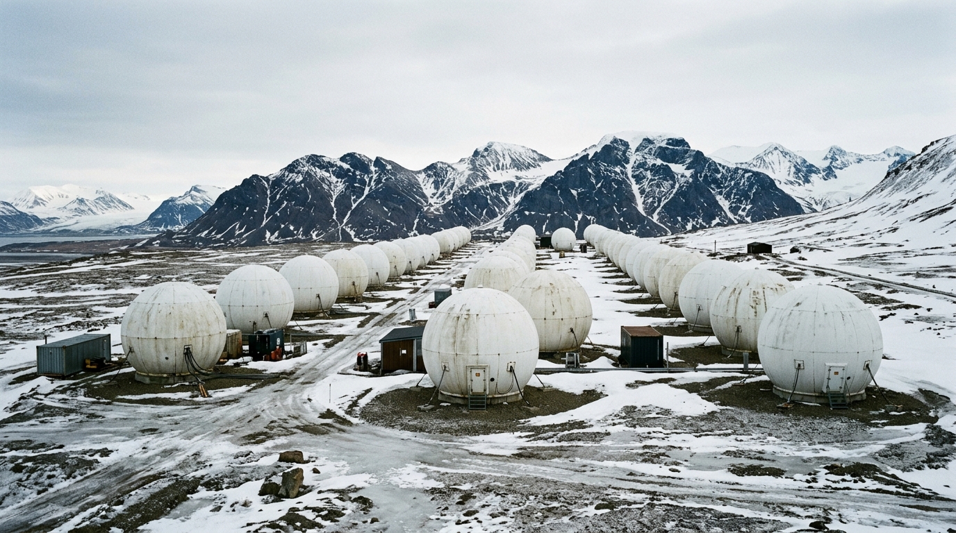
Each morning, when you check the weather app on your smartphone before deciding between a umbrella and sunglasses, you probably have no idea that part of that forecast depends on a windy mountainside lost hundreds of kilometers from the North Pole. The problem is that almost all the satellites that scan our planet can only transmit their data at very precise moments, during extremely short overpass windows. The reason for this constraint lies in the very physics of polar orbits, which force satellites to continually fly over the same extreme regions of the globe. To bypass this limitation, Norway, since the late 1990s, conceived a bold yet discreet idea: installing a gigantic network of antennas on a frozen plateau in the Svalbard archipelago. Since then, this remote corner of the Arctic has become, almost secretly, one of the most strategic points in the entire global space infrastructure.
- Thanks to its extreme latitude (78°13′ N), the SvalSat station captures polar-orbiting satellites on 14 out of 14 passes each day, versus just 10 out of 14 for a station like Tromsø
- Founded in 1997 on the Platåberget plateau and operated by KSAT, SvalSat now counts more than 160 parabolic antennas and shares a comparable capacity only with TrollSat in Antarctica
- SvalSat feeds major programs such as Galileo and Copernicus (ESA), NASA’s Near Earth Network, as well as NOAA and JAXA, playing a key role in global meteorology, sea-ice mapping, and maritime surveillance
- 78°13′ north: The Point on the Globe Where Everything Changes
- A Geographical Position That Changes the Equation
- 150 Antennas to Capture 14 Passes on 14, Where Others Top Out at 10
- When an Arctic Valley Decides the Weather of the Whole Planet
- Beyond Climate: Navigation, Polar Mapping, and Global Communications
- SvalSat, This Quiet Lock Keeping the World Connected
78°13′ North: The Point on the Globe Where Everything Changes
On a map, it’s hard to imagine that this tiny point at 78°13′ North latitude could carry such significance. And yet, it is precisely there, on the Platåberget plateau near the small town of Longyearbyen, that one of the most discreet yet powerful installations in the global space sector stands. The SvalSat station, founded in 1997, has grown steadily since its creation, when it counted only a handful of multi-mission installations. Today, the site boasts more than 160 parabolic antennas, raised toward the Arctic sky like a forest of metal watching for the slightest signal from space.
This choice of location is by no means incidental. Norway has leveraged a remarkable geographic setup to transform a harsh, wind-swept territory, plunged into polar night for part of the year, into a major technological asset. What might look like a simple latitude detail is in fact the cornerstone of the entire system.
A Geographical Position That Changes the Equation
To understand the value of such a site, one must consider how satellites in low Earth polar orbit operate. Unlike geostationary satellites that stay fixed above a single point on the equator, these devices race around the Earth, sweeping over the poles with each revolution. The result is that they regularly pass over polar regions, far more often than any other area of the globe.
That is precisely what Norway has managed to exploit. Thanks to its extreme position, the Svalbard station enjoys a unique advantage: it can communicate with these satellites at each of their daily passes, i.e., 14 times per day, without exception. To grasp the magnitude of this performance, compare it with a more typical polar station like Tromsø, which manages to capture only 10 passes out of 14. This difference, which may seem minor on paper, completely changes the game when it comes to real-time retrieval of vital data for meteorology, navigation, or environmental monitoring.
150 Antennas to Capture 14 Passes on 14, Where Others Top Out at 10
This extraordinary capacity is by no means accidental. It directly stems from the proliferation of antennas installed on the site over decades. Each antenna is dedicated to a specific mission or satellite and must be ready to capture a signal during a notably brief communication window: about 15 minutes, the time it takes for the satellite to cross the coverage zone before disappearing behind the horizon again. Fifteen minutes, not a second longer, to transmit terabytes of data collected in orbit.
That is why there is a proliferation of antennas on the frozen plateau: the more there are, the more the station can track different satellites simultaneously and avoid losing a single byte of information. The operation of this site is handled by KSAT, a joint venture born from the partnership between Kongsberg Defence & Aerospace and the Norwegian Space Centre. Such a highly specialized know-how is matched only by one other station in the world with a comparable capacity: Troll Satellite Station, located in Antarctica. Together, SvalSat and TrollSat form the only ground infrastructures able to observe a polar-orbiting satellite on every revolution, effectively creating a two-ended lock around the planet.
When an Arctic Valley Decides the Weather of the Whole Planet
Take a step back to measure the tangible impact of this installation on our daily lives. A large portion of the data feeding global weather models passes through the antennas on this Norwegian plateau at some point. Without this infrastructure, the weather forecasts we consult daily, especially during periods when conditions are capricious like at the start of autumn, would be significantly less precise and responsive.
This role extends far beyond Norwegian borders. The station is part of a much broader network, KSAT, spread across 28 sites around the world. Yet SvalSat remains the jewel, the centerpiece that enables this network to operate at full capacity thanks to its unmatched geographic position.
Beyond Climate: Navigation, Polar Mapping, and Global Communications
Meteorology is only the visible tip of the iceberg, so to speak, in a context as polar as this. SvalSat also forms a crucial link in NASA’s ground infrastructure through the Near Earth Network, while the European Space Agency (ESA) has its own parabolic antennas there to collect data from Galileo and Copernicus, two programs central to satellite navigation and environmental monitoring across Europe.
Other major organizations complete this roster of prestigious clients, such as the American NOAA, focused on oceans and atmospheric studies, or Japan’s JAXA. Through these multiple connections, the Norwegian station contributes both to precise sea-ice mapping and to global maritime surveillance, two issues that have become particularly sensitive as Arctic traffic tends to grow.
SvalSat, This Quiet Lock Keeping the World Connected
Ultimately, what strikes most about SvalSat’s history is the contrast between the site’s discreet nature and the scale of its influence. Few realize that a simple frozen plateau, whipped by Arctic winds, concentrates such a density of critical technologies for the functioning of our connected world. Since its founding in 1997, the Svalbard satellite station has established itself as the largest commercial ground station in the world dedicated to polar-orbiting satellites, a status won just as much by its extreme position as by Norway’s steady investment in the site over the years.
In short, it is hard to imagine a more telling symbol of our technological dependence: a tiny point on the map, tucked away at 78 degrees North, yet capable of weighing on the accuracy of weather forecasts read halfway across the globe. The next time you look up at the sky before stepping outside, a thought for this Arctic plateau may not be misplaced. One question remains worth pondering: at a moment when satellite traffic is exploding and new space powers are emerging, can Norway’s quasi-monopoly on this geographic niche stay as central for much longer?
