
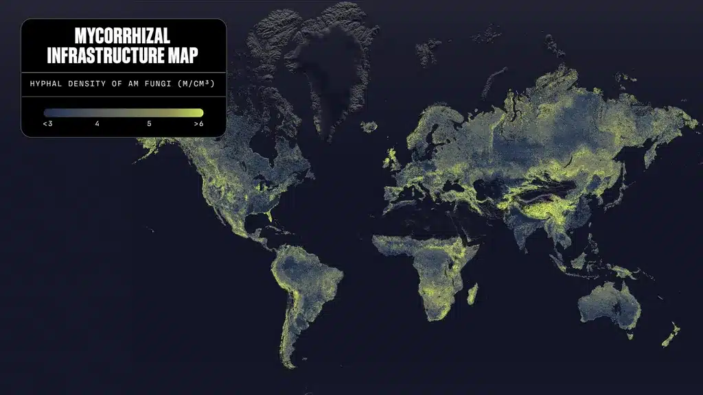
Under our feet lies a vast network of fungi so expansive that if you laid the filaments end to end, it would cover 10% of the Milky Way’s diameter. Researchers produced the first global map of this invisible forest — and their most surprising discovery lies beneath wild meadows, not under forests.
What you will learn
- Why wild meadows host the planet’s highest fungal density
-
An invisible highway beneath our feet
Arbuscular mycorrhizal fungi live in symbiosis with nearly all terrestrial plants. They supply nitrogen and phosphorus in exchange for carbon, forming a network of microscopic filaments called hyphae that stretch beneath almost the entire surface of the globe.
Until now, no one knew where this network was densest. Justin Stewart, a biologist and the lead author of the study published in Science, sums up the problem: it’s like knowing that 100 million cars travel daily on Earth without knowing the road network that carries them.
A map built from 16,669 samples
To fill this gap, the team compiled data from 16,669 soil cores drawn from 322 previous studies, spanning all continents and nine different biomes. From these field data, an artificial intelligence model then predicted fungal density for every square kilometer of arable land on the globe, crossing climate, soil chemistry, and vegetation.
The result is beyond imagination. The average hyphal density in the topsoil layer reaches 4.4 meters of hyphae per cubic centimeter. Laid end to end, these hyphae would stretch across about 110 quadrillion kilometers — nearly a billion times the Earth–Sun distance, or roughly 10% of the Milky Way’s diameter.
The surprise of wild meadows
The most unexpected finding concerns alpine and floodplain meadows, like Florida’s Everglades. In the first 15 centimeters of their soil, around 40% of the world’s fungal biomass concentrates — with an average density of 6.6 meters per cubic centimeter, the highest recorded.
Stewart states it plainly: this is the planet’s densest fungal forest, and it lies beneath wild meadows. This result upends how we think about the distribution of life on Earth—and places these meadows among essential carbon sinks, on par with forests.
An urgent conservation issue
The problem, Stewart notes, is that these meadows are disappearing rapidly, precisely because it is easier to pull up grass than to fell a tree. Their destruction could potentially release a portion of the 4.3 billion tonnes of CO₂ equivalent that these fungi absorb each year — about 11% of global fossil fuel emissions in 2021.
Intensive agriculture halves the density
The map also reveals the impact of certain farming practices. The arable layer of cultivated lands shows a density roughly 50% below the average, with 3.8 meters per cubic centimeter under cultivated trees — the lowest value measured.
Researchers could not isolate precisely which practices are responsible, but they suspect fungicides and nitrogen and phosphorus fertilizers, which would reduce the plants’ symbiotic affinity for these fungi.
A foundational step, not an endpoint
External experts praise the work as “foundational,” making a significant portion of the invisible visible. Some regions — tropical forests, deserts — still require more data, and the team plans an update of the map within the next five years.
Beyond static mapping, researchers stress that understanding the dynamics of this network is also required — how quickly the hyphae grow and die — in order to truly integrate its role into the global carbon cycle.
The study is published in the journal Science.
