
Under the fields of Charente-Maritime, at a depth of 15 meters, lies a work that Rome carved into the rock more than two thousand years ago. The aqueduct of Saintes, one of the oldest in France, measures 17 kilometers and remains out of reach to the general public, buried underground. Nobody can see it. Almost no one. And it is precisely this paradox that makes it so fascinating.
Key takeaways
- A Roman city of 6,000 inhabitants commissioned a colossal work whose route extends over 17 kilometers
- Roman engineers maintained a slope of less than 1 mm per meter along the entire distance: how did they measure with such precision?
- The monument has been classified as a heritage site since 2011, protected by its depth, but its final secret remains unsolved
A Gaulish capital thirsty for grandeur
Mediolanum (Saintes in Charente-Maritime) was the capital of Gallia Aquitania at the beginning of the High Roman Empire, and around 20–10 BCE it equipped itself with its first aqueduct, the first in the new province of Aquitaine, to feed the baths and public fountains of the city. An ancient metropolis that played in the same league as Lyon or Bordeaux, with the urban ambitions that accompany it.
The first aqueduct, built under the reign of Augustus by Roman soldiers, but also by masons, plasterers, and stonecutters, supplied water to the 6,000 to 8,000 inhabitants of Mediolanum. The oldest aqueduct, built at the very end of the 1st century BCE, brought water from Font-Morillon, located in the present-day commune of Fontcouverte. Sixteen kilometers from a forest spring to the city’s baths: at the time, it was the equivalent of a high-speed rail project.
But the city grew. By the mid-1st century, a new aqueduct allowed Saintes to receive the abundant waters from the sources of Venérand and Douhet, located about fifteen kilometers away, to ensure a flow of 120,000 m³ of water per day. Forty times more. The Roman engineers did not do things by halves.
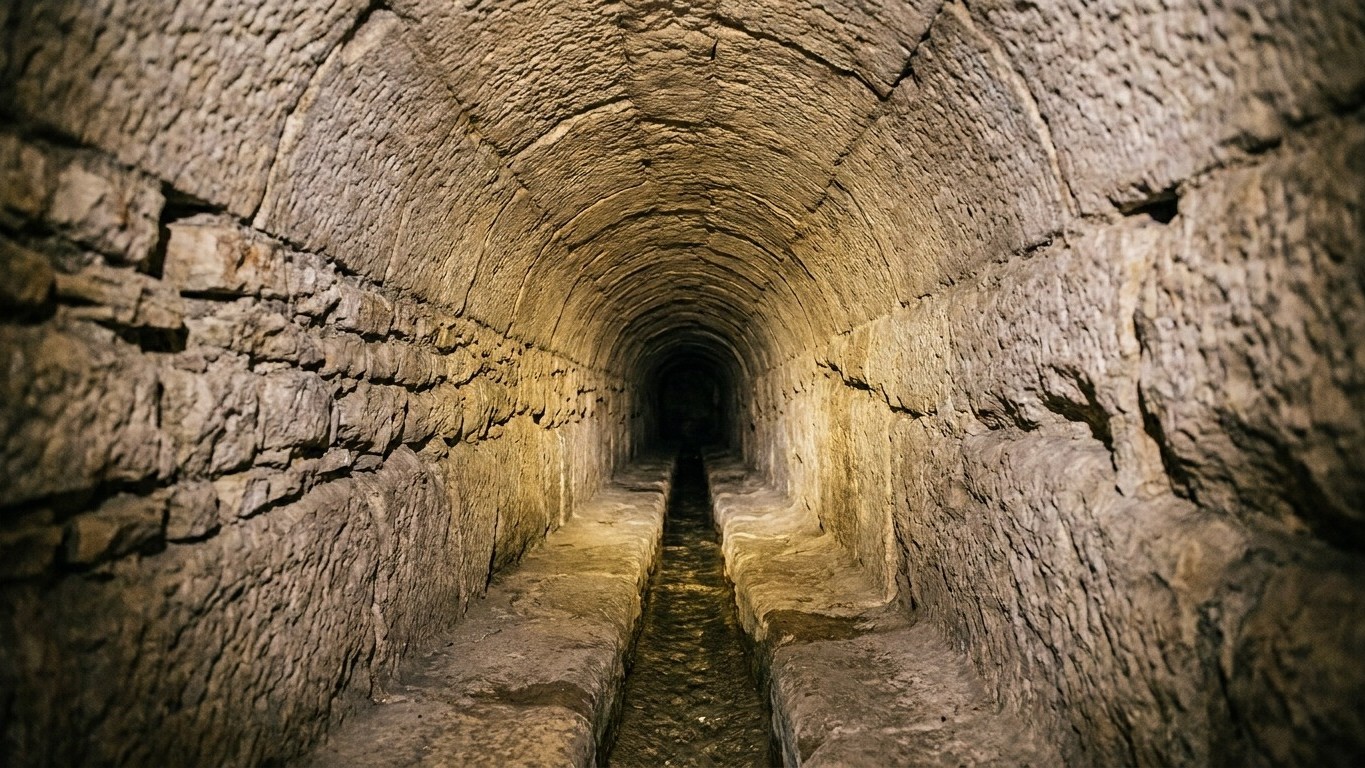
An underground genius carved in the limestone rock
The aqueduct is located 90% underground; the only above-ground section sits on the Saintes golf course, where the old arches of the aqueduct bridge rise. What is visible from the surface thus represents only a tiny fraction of the monument. The rest is a parallel world dug beneath the vineyards and fields of wheat.
Alternating between tunnels, channels or bridges depending on the terrain’s morphology, the water flows by gravity along a gentle, regular slope: less than 1 mm per meter. This technical detail deserves attention. Less than a millimeter of elevation change per meter traveled. To maintain this constant gradient over 17 kilometers across hills, ravines and limestone subsoil, the Roman surveyors achieved a feat of measurement that many modern engineers hold in high regard.
The underground gallery of Plantis, known as the Nine Wells, is vaulted in a full semicircle for 500 meters, with the channel established up to more than 17 meters beneath the surface. The majority of the structure is a masonry conduit at ground level or underground, carved into the rock and equipped with vents and inspection shafts. The aqueducts of Saintes thus include seven tunnels along their course. Seven. An underground network worthy of an ancient metro.
The height and width of the galleries vary from site to site and epoch to epoch; some exceed 2 meters in height and width while others are less than a meter high. One literally moves from an underground cathedral to a conduit where one must crawl. A student who descended there testifies: “it’s cramped, it’s well built and very well preserved for the era.”
Forbidden to the public, yet living beneath our feet
This precious vestige is not visible to the general public: it lies 15 meters underground and is accessible only via a makeshift elevator. No guided tours, no tickets to buy, no signage. The monument sleeps, protected as much by its depth as by general indifference. For millions of tourists who pass through Saintes each year to admire its Arch of Germanicus or its amphitheater, the aqueduct remains an abstraction.
Listed as a Historic Monument since 2011 in its entirety, it is the only Gallo-Roman aqueduct in France to benefit from such protection. Listed, protected, and yet invisible. The epitome of hidden heritage.
What makes the situation even more complex: the aqueduct’s route is known up to the city’s edge, at the places known as La Grève and La Grille, at the summit of a hillside overlooking the Charente valley from the right bank. But how the river was crossed and how the aqueduct reached the final distribution reservoir on the high part of the city, on the left bank, remains unknown. Two thousand years after its construction, the aqueduct still guards a part of its mystery.
3D to see what the eye cannot reach
The Charente-Maritime Society of Archaeology and History has undertaken to create 3D images to allow the general public to discover this gem of history. It partnered with the Sillac High School in Angoulême to model in 3D the underground portion, which will make it visible to the public. Students in a BTS surveying program thus lowered their measuring instruments into the bowels of Charente-Maritime, recording every vault, every hollow, every irregularity of the rock.
The construction techniques of the Roman tunnel, carved into the limestone rock, impress Antiquity specialists: there is a alternation of masonry-built sections with a barrel vault directly carved into the rock. Two techniques, used according to the local subsurface constraints, sometimes alternated just a few meters apart. An adaptability that counteracts the image of a Rome invariably uniform in its methods.
A third aqueduct, the chronology of which remains to be determined, was uncovered in 2010 and has not yet been dated. Bernard Bourgueil, of the Charente-Maritime Society of Archaeology and History, had restarted the excavations in 2003 with volunteer teams. Parallelly, Jean-Louis Hillairet, archaeologist at Inrap in Bordeaux, had discovered while surveying at Fontcouverte this third aqueduct superimposed on the first, as well as many wells filled in. Three successive hydraulic systems, built over several centuries, to feed a city that kept growing. Beneath the fields of Charente-Maritime, Roman history literally stacks up.
Sources: france3-regions.franceinfo.fr | museedupatrimoine.fr
