
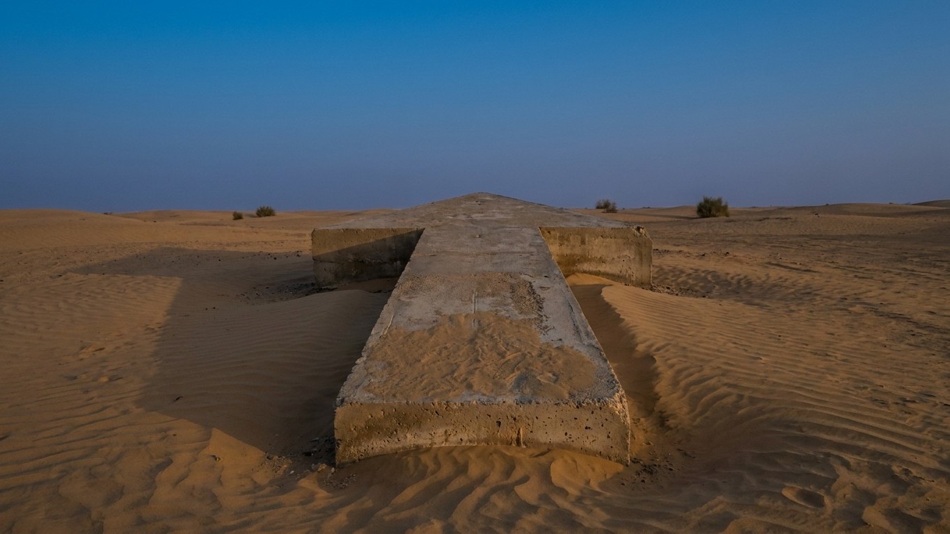
A desert, a pilot, no reliable compass. Between 1923 and the early 1930s, the United States built a sky‑high highway of navigation: 1,500 beacons spanning nearly 29,000 kilometers from New York to San Francisco, each crowned with a metal tower and backed by a giant concrete arrow. Today, the towers have vanished, scrapped during World War II, but dozens of these arrows lie dormant in the deserts of Utah, Nevada, and Wyoming, undisturbed for a century.
Key takeaways
- An air navigation system built entirely from desert lights replaced radio
- The metal towers vanished mysteriously during World War II
- The concrete arrows endure for a century, frozen in time
Fly at Night Without Getting Lost
It all begins with a very practical challenge for the U.S. Postal Service: air mail stops at sunset. The first night flight of airmail began on July 1, 1924. Before then, mail had to be transferred to trains at night. With illuminated airways, planes could fly through the night, cutting transcontinental delivery time by two business days. The stakes were not only commercial but strategic: proving that aircraft could replace rail over the long haul.
The system grew rapidly. It eventually counted 284 beacons, and with a deadline set for June 1925, the 4,289‑kilometer illuminated air route between New York and San Francisco was completed. Two years later, the network extended to Salt Lake City, Los Angeles, Las Vegas, Atlanta, and Dallas. In 1933, it peaked at 1,500 beacons spanning 29,000 kilometers of airways. A monumental project, carried out at a breakneck pace, with aspiring airmail pilots even taking part in the construction, including through harsh winters.
A Ground Arrow, a Beacon in the Sky
Each station followed the same principle, simple and devastatingly effective. On the ground, a concrete arrow pointed toward the next beacon, ten to fifteen miles ahead. The system included more than 1,500 illuminated beacon markers, spaced roughly 10 to 15 miles apart, pilots following the arrows by day and navigating from beacon to beacon using powerful rotating searchlights at night—a primitive form of an aerial highway. In the center of the arrow stood the metal tower, crowned by a beacon visible for tens of kilometers. A 15‑meter tower lit up the silhouette as soon as all other lights had vanished, with each arrow spaced about ten miles from the next and pointing toward the location of the next beacon.
The setup was not merely a painted arrow on the ground. Where no electrical connection existed, a generator was housed in a small building, which sometimes also functioned as a weather station. Some roofs of these huts even displayed the beacon’s number, an extra confirmation for the pilot that he was following the right route. No radio, no sophisticated instruments: just eyes, a map, and this chain of lights blinking in the dark like a rosary of beacons laid out in the desert.
The Reign of Concrete After the Death of Metal
As clever as the system was, it carried its own expiration date. By the mid‑1930s, radio made it obsolete. In the 1930s, advances in navigation and radio technology allowed flight without ground-based guidance, and the airpost beacon program closed in 1933, with technological progress and the high operating costs rendering it redundant. World War II delivered the final blow to the metal structures. During the war, most of the remaining towers were dismantled so that the steel could be used for the war effort, and to prevent the enemy from using them for navigation. In a few years, this continental network of lights again became invisible from the ground.
The concrete arrows, however, escaped this large cleanup. The steel beacon towers were taken down and recycled, mainly during World War II when steel was scarce, but the concrete arrows had no salvage value, so it was cheaper to leave them in place. The result: a century later, you can still walk up to them in Nevada, Utah, or Wyoming, often after several kilometers of rough terrain. Near Reno, one of them—the Mogul Arrow—becomes reachable after a round trip of nearly ten kilometers. In Wyoming, at Sweetwater or near the ghost town of Bryan, other arrows wait, barely eroded, in the middle of nowhere.
The arid climate did the rest of the preservation work. In dry regions like Nevada, Arizona, and Utah, the dry climate slowed erosion and sparse vegetation could not reclaim the land, so the concrete poured in the 1920s remained visible for generations with relatively little change. One witness even recalls that the ground around a Wyoming arrow was deliberately salted at the time to prevent vegetation from obscuring its silhouette seen from the sky—a trick that still works, decades later.
A Last Bastion in Montana
What stands out is that the system did not vanish everywhere. Montana, whose rugged terrain still disrupts some modern electronic gear, long kept a handful of updated beacons operational. Nineteen modernized beacons remained in service in Montana until 2018, maintained by the State Department of Transportation’s aviation division. A century after their invention, these ground beacons still served small aircraft traveling between mountain passes. A reminder that a technology deemed obsolete is never entirely useless, as long as a rugged landscape and clear skies stay indifferent to progress.
Sources: avoidingregret.com | 99percentinvisible.org
